Departure cityPRATS-DE-MOLLO-LA-PRESTE
Arrival cityPRATS-DE-MOLLO-LA-PRESTE
BeaconingYellow PR (short hiking trail)
Altitude665
Altitude1629
Circular routeyes
Topographical guides
Les pyrénées-orientaleshttp://www.chamina.com/produit/les-pyrenees-orientales-102/
Map referenceIGN TOP25 2349 ET
Files
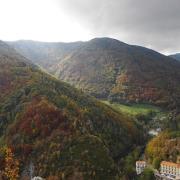
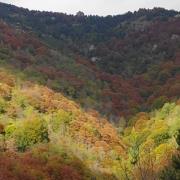
Hiking N ° 20 - Guide to the hiking trails of Haut-Vallespir. Beautiful hike loop with climb in a beech forest and descent into the cool forests. Route on the border ridges, with stunning panoramic views of the Spanish Garrotxa, the peak of Costabonne and the Esquerdes de Rotja. Departure from La Preste car park (1,100 m). Leave the vehicle at the La Preste car park, see the departure sign for the hikes. Hiking sheet: Free download in the "Download" section of the site Sold by the unit only at the ticket office of the Tourist Office card or photocopy
Labels and brands
PR - FFR
Groups welcomeyes
Pets welcomeyes
Contact
Telephone